


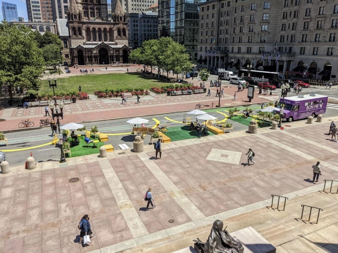
The portion of Dartmouth Street between the Boston Public Central Library and Copley Square was closed to cars from June 7 to June 17 as part of Copley Connect — a pilot program testing pedestrian-only streets in Boston’s Back Bay neighborhood.
Only emergency vehicles and food trucks were permitted on this section of Dartmouth Street, which connects Boylston Street and St. James Avenue, for the duration of the project. Café tables, turf grass, and public activities — including an open drum circle and a community tea party — replaced traffic.
Courtney Goode, founding principal and owner of Goode Landscape Studio — which designed the Copley Connect pop-up park — said the 10-day pilot program was meant to solicit feedback on how citizens want the space to be used, collect data on how designating pedestrian-only streets will affect traffic patterns, and test designs for the possible, long-term installation of a car-less and communal street.
“The whole thing is really an experiment,” Goode said.
The Copley Connect project – which bridged the gap between Copley Square and the exterior of the Central Public Library – was organized in coordination with the plans to renovate both those spaces.
“It’s like stitching the two iconic public spaces on either side of it into one continuous public space,” Goode said. “That’s why we’re calling it Copley Connect.”
Bob Oppenheim — a Back Bay resident— said he had “mixed” feelings about Copley Connect. He said the street closure has led to detours and traffic congestion that he worries might increase carbon emissions.
“I think the intentions are good, but I don’t think it’s really well conceived,” he said.
Goode said by “prioritizing people over cars” and reducing the amount of paving on this block of Dartmouth Street, the city may be able to decrease urban heat island effect and provide a cooling center to keep people safe in heat intensified by climate change, she said.
Urban heat island effect is a phenomenon that occurs in cities. Temperatures in these areas become hotter than outlying areas because buildings and roadways absorb and re-emit the sun’s heat more than natural landscapes, according to the Environmental Protection Agency.
The space was also organized as a social setting. Copley Connect hosted a series of public events on the blocked-off street and provided additional seating to encourage mingling.
Taylor Cain — who was walking home from work when she stopped at the Dartmouth Street pop-up — said the quieter street was a nice change of pace from downtown Boston.
“I never imagined seeing a street used in this type of way, but it’s really cool,” Caine said.
The pedestrian-only area additionally provided extra space for foot traffic to Copley Square events like the bi-weekly farmer’s market and open-air viewing of the Celtics NBA Finals.
Ted Schwartzberg, Senior Planner at Boston Planning & Development Agency, said supporting community events in Copley Square and the Central Library is one of the main goals of renovating this block of Dartmouth Street. BPDA funded the Copley Connect project and organized it alongside the Boston Transportation Department, Parks and Recreation Department and Public Library.
“This time of year is when very special events like [the Celtics watch party], and we’re glad we had the opportunity to test out how the two spaces function in that environment,” he said.
Dartmouth Street is part of the route that connects Boston’s larger green spaces — including the Charles River Esplanade and the Arnold Arboretum.
William Moose, a transportation planner at the BTD said the results of the Copley Connect pilot will influence how the BPDA and BTD proceed with efforts to make Dartmouth St a more cohesive route between the city’s major parks.
“One of our longer-term goals is to try to make this a better pedestrian and bicycle corridor, kind of a north-south, active transportation spine, connecting all those green spaces,” he said.
Moose added the program utilizes a tool to collect traffic data using cellphones, which analyzes the direction, flow and quantity of people and cars.
“I think it’s really interesting and important for cities to try these kinds of things,” Goode said. “It’s truly an experiment.”