Honks and profanity are surefire ways of letting off some five o’clock steam, but when all is said and done, there’s a reason why the phrase “stuck in traffic” sticks. But the inch-by-inch stop-and-go might have just gotten more avoidable, with a new formula for traffic flow prediction developed by researchers at Massachusetts Institute of Technology and University of Notre Dame, among others.
“We all know it’s an important topic,” said Marta González, an assistant professor of civil and environmental engineering at MIT and one of the study’s researchers. “Traffic was something that we could work on to try and improve foundations.”
But highly congested traffic zones consume much more than just a commuter’s time, said Jonathan Levy, a professor of environmental health at the Boston University School of Public Health. High concentrations of vehicle emissions can lower air quality and even affect physical health.
“Congestion hot spots can become air quality hot spots within a short amount of time,” Levy said. “If you as an individual are stuck in a car and you’re driving in traffic, you’re spending more time being exposed to potentially higher levels of air pollution. The same thing goes for bikers and pedestrians along that roadway.”
Ultrafine particles and combusted pollutants from gasoline and diesel fuel are the road’s most common threats to air quality, Levy explained. In urban areas, such as Boston, motor vehicles contribute a large percentage of both.
“Traffic is really the dominant source of those,” Levy said.
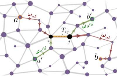
In order to collect data for the study, which was published on Nov. 6 in Nature Communications, researchers first pulled population distribution, work location and highway network data from the U.S. Census Bureau. With this information on hand, the team could model their algorithm, which aims to prevent inconveniences and environmental stressors triggered by the onset of traffic, based on human destination sites.
These sites within the traffic flow prediction formula were then categorized into “absorbers” and “emitters,” with absorbers marking daily locations that draw in large numbers of people — like BU, for example — and emitters marking the places where people live. Average measures of daily commuters between any two given points were then corresponded to a specific voltage in an electrical system — the higher the voltage, the higher the occurrence of traffic.
“It’s very powerful because it connects the traffic with…population distribution in quantity,” González said. “This can help us to not only predict but explain why certain areas are more congested, and that helps to develop more route strategies.”
For BU students who live off-campus, travel time is the most pressing issue, compared to reducing emissions or improving physical health.
“It’s totally bad,” said Simone Rauch, a senior in the College of Arts and Sciences. “You can’t predict any traffic patterns ever. There’s always traffic everywhere, and it’s ridiculous.”
Rauch said she largely drives to see her horse multiple times a week, commuting from her apartment in Fenway to Hanover, a 40-minute drive south of Boston.
“It’s the worst on Storrow Drive and roads like that,” she said. “There are just too many people, and they’re redoing the bridges and the concrete all over Boston. Basically once you’re out of the city, you’re good.”
Kevin Huang, a sophomore in Sargent College of Health and Rehabilitation Sciences, said the research team’s traffic flow prediction algorithm could serve as a helpful tool for students who drive.
“Having an accurate prediction of when traffic starts and ends could help my schedule in terms of classes, extracurricular appointments,” said Huang, who commutes to campus from Winchester every day. “It would just make things a lot more convenient.”
The researchers are currently refining calculations for follow-up studies. González said a combination of GPS technology and the developed formula is in the works for attacking traffic’s most mundane consequences: sitting and waiting.
“It’s a win-win if people are getting through areas more quickly,” Levy said. “And saving time is obviously beneficial in its own right.”
Hannah Landers contributed to the reporting of this article.










































































David Gray • May 12, 2015 at 12:54 pm
Are Waze or Google Maps traffic information used in the most current study?
Is this or can this data be used by anyone to develop a traffic routing optimization algorithm?